The vegetation profiles represent a generalised picture of the landscape. Each profile presents a typical landscape sequence. For each landform the following information is listed:
- a schematic drawing showing the vegetation structure;
- the main Ecological Vegetation Classes (EVCs) associated with it;
- a brief description of the vegetation;
- a brief description of the associated geology and soils;
- one or two location examples where intact native vegetation can be observed (if known);
- a link to a list of plant species grouped into trees, shrubs and groundcovers that are local to the area, suited to similar sites and can be used as a guide for planting projects.
It should be noted that the landforms presented may occur in different sequences in some areas. The profiles have been compiled to represent typical sequences, but these may not be the only ones.
To assist you to identify the appropriate vegetation profile and species list, Understanding Your Planting Profile , is suggested as a first step.
Use the profile name and descriptions to determine the ones most suited to your site. Click on the landform name to view the species list.
The vegetation in the Victorian Riverina revegetation zone has been divided into five profiles containing different vegetation types.
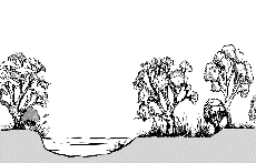
Rivers & Floodplains
Floodplain (flooding frequent with lengthy inundation)
| |
 |
| Geology |
Alluvial, loam soils. |
| EVC |
Sedgy Riverine Forest |
| Description |
River Red Gum forest or woodland with an understorey dominated with tussock grasses, sedges and aqautic herbs, which may be inundated for parts of the year on the frequently flooded terraces and floodplains of major rivers. |
| Species List |
Floodplain (flooding frequent with lengthy inundation) species list |
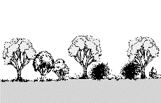
Banks and Floodplains of Goulburn and Broken Rivers
| |
 |
| Geology |
Alluvial, fertile sandy clay loam soil. |
| EVC |
Floodplain Riparian Woodland |
| Description |
River Red Gum woodland along the regularly flooding terrace of large, slow moving rivers. Consists of a tall shrub layer with a ground layer of aquatic herbs and tufted grasses. |
| Examples |
Hughes Ck, Stewart Park, Avenel. |
| Species List |
Banks and Floodplains of Goulburn and Broken Rivers species list |
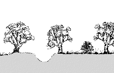
Elevated Floodplain of the Goulburn River
| |
 |
| Geology |
Alluvial, fertile silt and sand soils. |
| EVC |
Riverine Grassy Woodland |
| Description |
Open woodland of River Red Gum above a short, tussock grassy ground layer, sometimes with occasional sparse shrubs including chenopods. Occurs on floodplains of major rivers in a slightly elevated position on deposited silts and sands. |
| Species List |
Elevated Floodplain of the Goulburn River species list |
Return to profiles index