The vegetation profiles represent a generalised picture of the landscape. Each profile presents a typical landscape sequence. For each landform the following information is listed:
- a schematic drawing showing the vegetation structure;
- the main Ecological Vegetation Classes (EVCs) associated with it;
- a brief description of the vegetation;
- a brief description of the associated geology and soils;
- one or two location examples where intact native vegetation can be observed (if known);
- a link to a list of plant species grouped into trees, shrubs and groundcovers that are local to the area, suited to similar sites and can be used as a guide for planting projects.
It should be noted that the landforms presented may occur in different sequences in some areas. The profiles have been compiled to represent typical sequences, but these may not be the only ones.
To assist you to identify the appropriate vegetation profile and species list, Understanding Your Planting Profile , is suggested as a first step.
Use the profile name and descriptions to determine the ones most suited to your site. Click on the landform name to view the species list.
The vegetation in the Upper Goulburn - Yea revegetation zone has been divided into two profiles containing different vegetation types.
Low Hills, Plains & Floodplains
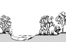
Floodplains
| |
 |
| Geology |
Alluvial, soils sandy clay loam. |
| EVC |
Floodplain Riparian Woodland |
| Description |
Tall River Red Gum woodland along the regularly flooding terraces of large, slow moving rivers. |
| Species List |
Floodplains species list |
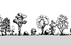
Plains
| |
 |
| Geology |
Alluvial, soils fertile ranging from loam to clay loam. |
| EVC |
Plains Grassy Woodland |
| Description |
Open woodland on the plains dominated by River Red Gum with a dense suite of grasses, sedges and herbs with a scattered shrub layer. |
| Species List |
Plains species list |
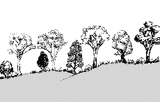
Low Hills
| |
 |
| Geology |
Sedimentary, range of fertile well drained soils. |
| EVC |
Grassy Woodland (Low Rises and Rainshadow) |
| Description |
Grey Box dominated woodland with Red Stringybark and Red Box. Open mid-storey shrub layer of wattles, and a diverse grassy and herbaceous ground layer. |
| Species List |
Low Hills species list |
Return to profiles index