The vegetation profiles represent a generalised picture of the landscape. Each profile presents a typical landscape sequence. For each landform the following information is listed:
- a schematic drawing showing the vegetation structure;
- the main Ecological Vegetation Classes (EVCs) associated with it;
- a brief description of the vegetation;
- a brief description of the associated geology and soils;
- one or two location examples where intact native vegetation can be observed (if known);
- a link to a list of plant species grouped into trees, shrubs and groundcovers that are local to the area, suited to similar sites and can be used as a guide for planting projects.
It should be noted that the landforms presented may occur in different sequences in some areas. The profiles have been compiled to represent typical sequences, but these may not be the only ones.
To assist you to identify the appropriate vegetation profile and species list Understanding Your Planting Profile , is suggested as a first step.
Use the profile name and descriptions to determine the ones most suited to your site. Click on the landform name to view the species list.
The vegetation in the Goldfields revegetation zone has been divided into four profiles containing different vegetation types.
Mitchellstown Swamps and Wetlands
Shallow Wetlands (seasonally dry)
| |
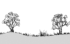 |
| Geology |
Alluvial and paludal, heavy clay soils |
| EVC |
Plains Grassy Wetland |
| Description |
Seasonal or intermittent wetland, meadow or marsh, with fringing River Red Gum and/or Grey Box. Typically species-rich on the outer verges but is usually species-poor in the wetter central areas. |
| Species List |
Shallow Wetlands (seasonally dry) species list |
Swamps
| |
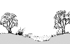 |
| Geology |
Alluvial and paladul, heavy clay soils. |
| EVC |
Red Gum Swamp |
| Description |
Open River Red Gum woodland dominated by sedgy or grassy-herbaceous aquatics and species tolerant of intermittent to seasonal inundation. |
| Species List |
Swamps species list |
Lunettes
| |
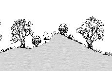 |
| Geology |
Aeoline sands, soils sandy to sandy loam. |
| EVC |
Sand Ridge Woodland |
| Description |
Open woodland dominated by Grey Box and Yellow Gum with a dense medium to small shrub layer and a range of annual herbs and grasses. |
| Examples |
Puckapunyal Military Area (northern end of Major Ck area around wetlands); |
| Species List |
Lunettes species list |
Return to profiles index